 NOAA
NOAA
Retreating glaciers: Can a warming climate increase tsunami risk?
This article covers a topic which was presented in the form of a poster (which you can view here) at the AGU fall conference 2020: discussing the massive tsunamis that can be caused by glaciers retreating due to climate change. The full paper, “Detection and Assessment of a Large and Potentially Tsunamigenic Periglacial Landslide in Barry Arm, Alaska”, from October 2020, by Dai et al, can be found here.
The 2020 AGU Fall Meeting was held in a virtual space because of the COVID-19 pandemic, and took place over an extended meeting period, from December 1-17, in a format that maximized participation across time zones. Across the world, over 25,000 participants registered from more than 110 countries, and if the total video content were watched end-to-end, it would have lasted about 4 months! The meeting included workshops and town halls, online talks, and virtual posters – of these, more than 140 sessions discussed tsunamis and their impact, even if that was not the main topic of the talk. Most sessions had pre-recorded presentations, with live (recorded) sessions focused on short overviews and moderated discussions. Poster sessions included text chats or short, live Q&A with presenters.
A mention of tsunamis will typically conjure up images of the deep ocean, earthquakes, and walls of water pushing steadily and relentlessly over low-lying coasts. But tsunamis can also occur in enclosed bodies of water. Though not as far-reaching, tsunamis in bays, lakes and fjords can be enormous – with vertical run-up measured not in tens of meters, but in hundreds. These mega-tsunamis sometimes occur after seismic disturbances like earthquakes or volcanoes, but the displacement of huge volumes of water is caused by the initial disturbance setting off a massive landslide (either starting underwater or falling into the water). Imagine a boulder being dropped into a swimming pool from the high dive. The highest known tsunami ever measured occurred in this manner in 1958 after a 7.5 magnitude earthquake set off a landslide at Lituya Bay, Alaska where run-up on nearby slopes reached 524 meters (1720 ft) above sea level.
")
A unique type of tsunamigenic landslide has caught the attention of scientists in recent years: those resulting from glacial retreat or permafrost melting due to climate warming. During ice ages the steady movement of massive glaciers carves and scours the earth beneath. During interglacial periods like the present, steep ridges and mountainsides thousands of feet high are exposed as glaciers move back to their more poleward positions. Glacier-carved valleys and rising seas from ice melt form deep fjords along the coast. The combination makes for stunning landscapes – but also potentially unstable ones if a warming climate changes the balance between land, ice, and ocean.
Glaciers retreating due to climate warming can leave behind newly “un-buttressed” slopes that are unstable and at risk of catastrophic failure in landslides. The network of fractures caused by thousands of years of ice movement make glacial territory especially vulnerable. Fjord water that replaces the retreating ice undercuts and further erodes the unprotected slopes. Mountainsides stabilized by permafrost can be subject to similar destabilization as thawing occurs.

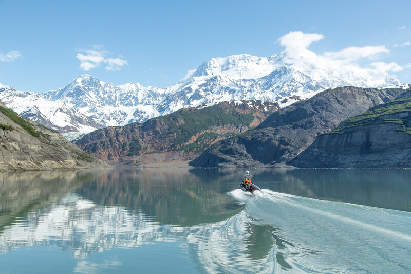
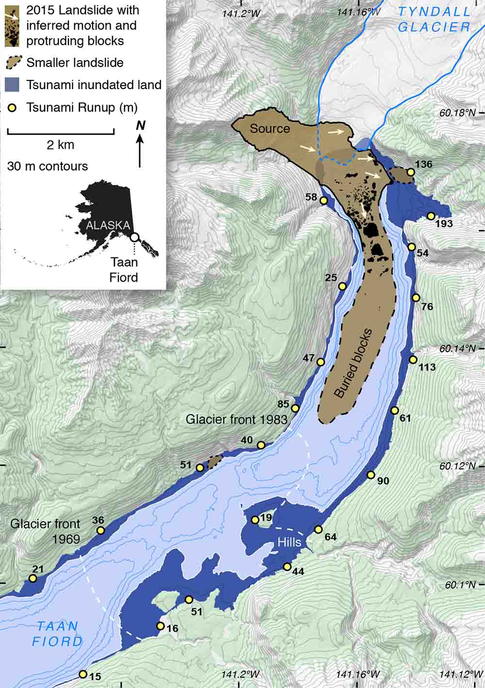
The Taan Fjord landslide and tsunami of 2015 is an example of glacial retreat destabilization that offers a case study of the risks and measures that can be taken to protect communities. Geologist Bretwood Higman of the non-profit Ground Truth Trekking and a large interdisciplinary team of scientists studied the slope failure that occurred at Tyndall Glacier, dumping 180 million tons of rock into Taan Fjord, and setting off a tsunami that inundated the surrounding hillsides as high as 193 meters (633 ft). Ten miles away, at the mouth of the fjord, the wave was still 15 m (50 ft) high. 20 square kilometers (8 sq miles) of forest was flattened. Fortunately, in this remote area there was no other property damage or casualties.
Analysis of prior satellite imagery and digital elevation models (DEM) revealed signs of slope deformation at least two decades before the landslide. Attention is now turning to analysis of this data to identify other glaciers with high landslide and tsunami risk which may be in more populated locales.
At particular risk are vessels in fjords, such as fishing boats, cruise ships, pleasure boats and kayaks. The extreme wave height (estimated at about 100 meters in Taan Fjord) and short wavelength of such tsunamis mean violent wave breaking is likely, as well as intense currents that could wreak havoc on even large craft.
Ohio State University researcher Chunli Dai, a specialist in remote sensing working with ArcticDEM and satellite data, joined forces with Higman to investigate signs of movement on the slopes of Barry Arm, a fjord on Prince William Sound and popular recreational area 60 miles from Anchorage. Barry Glacier has been retreating rapidly in recent years, creating conditions ripe for destabilization of the adjacent slope which rises 1000 m (approx. 3000 ft) between the Barry and Cascade glaciers.
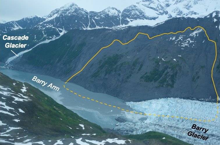 Comparing time series of satellite and DEM imagery revealed that the slope has moved horizontally 120 m (394 ft) between 2010-2017, resulting in 455 million cubic meters of unstable earth. The research team estimates that the combination of that mass of land and its 3000 ft elevation would cause tsunami waves hundreds of feet tall in the fjord and reverberate throughout Prince William Sound. The seaside town of Whittier, 25 miles away, could see water levels of 30 feet. Results of the study were recently published in Geophysical Research Letters and presented at the fall American Geophysical Union meeting (2020 virtual edition).

In response to these new findings about landslide and tsunami risks from retreating glaciers, Alaska state agencies, the U.S. Geological Survey, the National Oceanic and Atmospheric Administration, and the National Tsunami Warning Center are all working to further understand and mitigate the risks at Barry Arm and other locations. Plans are underway for installation of seismic sensors to warn of imminent collapse and water height monitors for tsunami detection, as well as developing models for landslide-based tsunamis in the area.
For more information:
Barry Arm Landslide and Tsunami Hazard (Public Safety)
Alaska Department of Natural Resources, Geological and Geophysical Surveys
https://dggs.alaska.gov/hazards/barry-arm-landslide.html
Retreating Glacier Presents Landslide Threat, Tsunami Risk in Alaskan Fjord (Slider image)
https://www.nasa.gov/feature/esnt/2020/retreating-glacier-presents-landslide-threat-tsunami-risk-in-alaskan-fjord
The 2015 Taan Fiord landslide and tsunami.
Higman, B., M. Geertsema, D. Shugar, P. Lynett, and A. Dufresne. 2019.
Alaska Park Science 18(1):6-15.
https://www.nps.gov/articles/aps-18-1-2.htm
The 2015 landslide and tsunami in Taan Fiord, Alaska.
Higman, B., Shugar, D.H., Stark, C.P. et al. Scientific Reports 8 (2018).
https://doi.org/10.1038/s41598-018-30475-w
Detection and Assessment of a Large and Potentially Tsunamigenic Periglacial Landslide in Barry Arm, Alaska. Dai, C, et al. 2020. Geophysical Research Letters.
https://agupubs.onlinelibrary.wiley.com/doi/epdf/10.1029/2020GL089800

![]()

Quick Links
![]()
![]()
![]()
Resources


Tsunami Awareness Poster
Available in English, Spanish, Chinese, French, Japanese, Korean, Portuguese, Singalese.

Global & Regional Hazard Maps
Tsunami Sources, Significant Earthquakes, Significant Volcanic Eruptions, Tsunami Icosohedron Globe.


TsunamiTeacher USA
Tsunami Basics
Also on YouTube
(w/closed captioning)
Learn the basics of tsunamis. Available in English, Samoan.